
Completed walking and cycling schemes
Information on completed walking and cycling schemes that we have completed across the county.
Arrow Valley (Redditch)
Scheme update
The works to widen and resurface the footways in Arrow Valley Park were completed in March 2022.
This project saw the widening of a well-used path along the top of Arrow Valley lake from a width of 2.5 m to 4 m. The route was undulating with differences in levels found across the same cross-section with areas of pooling evident after rain events.
The route became Local Transport Note (LTN) 1/20 compliant for shared use and offers a smooth and comfortable journey with no pooling and even surfaces.
The gradients were lowered to become Equalities Act compliant.
Non-British Standard bollards where removed and replaced with BS EN Passive safety ones.
The ecology along the route was improved by the spreading of wildflower seeds for pollinators.
The lighting of the route was upgraded to be more energy efficient with the fitting of LED lighting heads.
A dropped crossing was installed allowing members of the public with mobility restrictions, easier access onto the footpaths around the lake.

Diglis to Sixways (Worcester)
Scheme description
This scheme involved the extensive widening and resurfacing of this very popular active travel corridor and connecting links.
It links the City Centre directly with the extensive business parks and commercial sites on the northern fringes of the city, Shrub Hill Rail Station, Worcester Leisure Centre and a number of residential areas.
Despite increasing levels of usage, the route was too narrow and poorly surfaced in places, these required corridor-length upgrading (including surfacing, widening and waymarking improvements and installation of permanent walking and cycling counters for monitoring) to enable it to play a more strategic role to support increased levels of walking and cycling across the city and beyond.
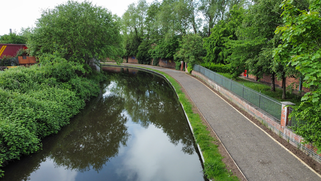
This project, in conjunction with Canal and Rivers Trust (CRT), saw the widening and resurfacing of the Birmingham and Worcester canal towpath between Friesland Close and Blackpole Road (Bridge 16-19).
The works included the widening and resurfacing of the towpath to create a sealed surfaced path suitable for use all year round. The previous surface was a stone composition which had become eroded and left large areas of pooling after rain events.
This now gives better connectivity to industrial estates on the peripheries of the City and also opens up green spaces such as Perdiswell Park.

Kidderminster
Scheme update April 2024:
The works relating to the Emergency Active Travel fund were completed in August 2022.
The 950m of widening and resurfacing of the Staffordshire and Worcestershire Canal Towpath linked into the successful Wyre Forest District Councils Levelling Up Fund bid which continued the widening and resurfacing of the towpath for a further 1.6Km towards Stourport-on-Severn.
The works have brought year-round access from the north of Kidderminster to the Town Centre and beyond.

Sabrina Bridge
Sabrina Bridge in Worcester was first opened in 1992. Since then the footbridge has been incredibly well used, providing a link between the city centre to businesses, amenities and university buildings on the west side of the river.
The refurbishment of this bridge was a high priority for the Council, in particular the replacement of the bridge deck itself.
The new bridge deck is a composite material. The material was specifically chosen as it performs much better in wintery conditions than the current wooden slats.
The new decking will also provide more stability to the structure of the bridge. Works were completed at the end of 2020.

Stanford bridge
Improvement works are now completed on the 1905 historic Stanford bridge, located over the river Teme in the village of Stanford.

The bridge, restricted to pedestrians and cyclists, is an early example of reinforced concrete work and is a Listed Grade II Monument.
Repairs were required to improve the condition of the structure and included a full refurbishment of the main span and brickwork flood arches.
The works, delivered by us with our contractor and Designer, Ringway and Jacobs respectively, have not significantly changed the visual look of the bridge with materials matching the existing as close to its original form as possible.
The main challenge was delivering the work under the three-tonne weight limit, as the weight of the scaffold hanging off the bridge posed a risk to the structure.
So, a phased approach was taken, scaffolding the two end abutments first, transferring the weight off the main span, followed by the middle section.
Together with alternative material such as aluminium, kept the weight to a minimum. The risk of falling debris was prevented by a full encapsulation of the scaffolding.
The concrete bridge replaced a single span iron structure, a typical example of the transition of Iron bridges to the newer concept of reinforced concrete.
The bases of piers visible during low water levels are likely to be those of the brick bridge of the early 18th century.
The earliest recorded bridge in this location was a wooden one built in 1548.
Wyre Road (Pershore)
Scheme update
Works to make walking and cycling improvements on Wyre Road in Pershore are now complete.
The works to make improvements to the cycling and walking provision in the area, included the construction of a cycle/foot new path from Wyre Road roundabout to Station Road on the northern side of Wyre Road, the installation of a new kerb line, improvements to drainage and additional street lighting.
The cycle/foot path will provide a link between Station Road and the new Pershore Northern Link Road, at which works continue ahead of completion this summer.

 Facebook
 Twitter
 Email
Email WhatsApp
 Messenger